Al Studt
When you need a tool such as a halligan bar, you either already have it or you get it from your vehicle. What about geospatial tools? When a street address fails, when off road, or in the wilderness, what should be your number one go-to tool? For ease of use, and consistent with military operations since 1949, the tool for positional reporting and navigation for land-based operations is the United States National Grid (USNG).
What Is It?
USNG, effectively the same as the Military Grid Reference System (MGRS), is a derivative of Universal Transverse Mercador (UTM), which hikers employ routinely. USNG can be displayed on your smartphone easily, but a GPS receiver is not mandatory. Paper maps still rule, and all should include USNG grid lines when created. Computer-aided dispatch and mobile data terminals can also be made to display properly labeled grids. All maps need a grid system to be most usable. Maps already in use or those found in office supply or convenience stores typically display noninteroperable “bingo” grids. Maps from the Internet are generally devoid of grid lines and thus are effectively just pictures. What responders need are properly labeled, gridded USNG maps.
USNG can specify areas of one kilometer (km), 100 meters, or 10 meters with as little as four, six, or eight digits, respectively, and without dashes, decimal points, or degrees. This facilitates easier radio communications of coordinates.
16S FH 1152 2426 represents a coordinate with precision of 10 meters square (33 feet by 33 feet). When the components 16S FH are truncated by local users, 115 242 represents 100 meters square (330 feet by 330 feet) and 11 24 is the one-km square area. In other words, 1152 2426 is a location 52 percent right and 26 percent up in the one-km grid 11 24.
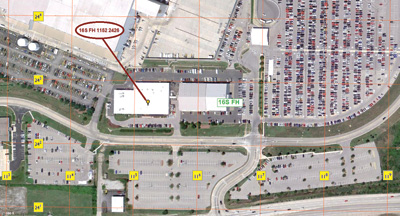 |
| (1) This is a USNG gridded map example and coordinate 16S FH 1152 2426. (Photo courtesy of the author.) |
Tactical Use
USNG area references can be used tactically. The 100- or 10-meter grids can identify helispots or homes in combination with or in place of the paradigm of street address, as appropriate. An out-of-area strike team has no familiarity with local addresses, but when versed in the simple x-y nature of the USNG, finding a location can be less stressful and certainly more efficient.
USNG is designated by the states of Minnesota and Florida as the preferred coordinate system. Federal agencies comprising the National Search and Rescue Committee have designated USNG as the coordinate system for all land search and rescue operations as of November 2011.
When the street addressing system is unfamiliar, blown away, burned over, flooded, or nonexistent in rural or wilderness areas, the interoperable coordinate system to report position and to navigate by is the USNG.
AL STUDT, CFPS, Instructor III, is a lieutenant with Cape Canaveral (FL) Fire Rescue and a communications and structures specialist with the FL-TF4 USAR team, based in Orlando, Florida. He is a 29-year fire service veteran and has been deployed to areas devastated by Hurricanes Andrew and Katrina, where common landmarks and navigational aids were missing. He has been an advocate and instructor of the United States National Grid since 2007.